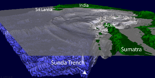
Digital image showing cross section of the Java or Sunda trench, and the wave heights of the tsunami (gray peaks near the shoreline). (Courtesy USGS).
Today, December 26, 2014, is a somber anniversary. Ten years ago today, during the Christmas holidays, the southern regions of Thailand and the north coast of Sumatra was heavily populated, and also crowded with tourists seeking relief from Northern Hemisphere winters by enjoying the sun and pristine beaches. It was the day after Christmas (Boxing Day in the British calendar) when a violent earthquake struck 160 km (100 miles) off the northwest coast of Sumatra. It had a moment magnitude of 9.2, the second largest earthquakes ever recorded on a seismograph, and lasted between 8 and 10 minutes, the longest duration of shaking ever observed. The entire region vibrated by as much as 1 cm (0.5 inches), and triggered sympathetic earthquakes as far as Alaska. As the Indian plate is pushed under the Burma plate, it produces a huge subduction zone that is responsible for the island nations of Indonesia and Malaysia. The fault line of this plate boundary formed a rupture about 400 km (250 mi) long and 100 km (60 mi) wide, which was located 30 km (19 mi) beneath the seabed—the longest rupture ever caused by an earthquake. The energy released by the quake was about 550 million times more powerful than the A-bomb that wiped out Hiroshima.
Although the earthquake shook the countries of Thailand, Indonesia, and Malaysia that morning, many people recovered quickly, or ignored it and went on with their day. Just minutes after the earthquake, however, the effects of the submarine quake began to show up on the western shore of Thailand and Indonesia. First, the sea level dropped abnormally low, and the coastal reefs and seabed were exposed. People ran out for the easy fishing, only to discover to their horror that the unusually low sea level was a trap, because it was closely followed by a 30-meter-tall (100 foot tall) wall of water known as a tsunami, or seismic sea wave.
The largest loss of life was along the western coast of Indonesia, Malaysia, and Thailand, but the waves propagated westward across the Indian Ocean at a speed of 500 to 1,000 km/h (310 to 620 mph). Within 3 hours, the waves reached Sri Lanka and the coast of India. Seven hours later it reached the coast of Somalia in Africa, where the damage and loss of life were worse than in Bangladesh, much closer to the source of the waves (but not in the direct path of the main wave propagation). The tsunami was noticed as far as the western coast of South Africa, some 8500 km (5300 miles) away, and propagated out into the Pacific Ocean as well, although not with as much energy.
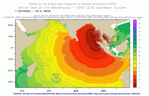
Map showing travel times (in hours) that the tsunami took as it crossed the Indian Ocean. (Courtesy NOAA).
One account of the tsunami as it reached Sri Lanka was reported by Michael Dobbs of the Washington Post that same evening:
Disaster struck with no warning out of a faultlessly clear blue sky. I was taking my morning swim around the island that my businessman-brother Geoffrey bought on a whim a decade ago and turned into a tropical paradise just 200 yards from one of the world’s most beautiful beaches on the Sri Lankan mainland. I was a quarter way around the island when I heard my brother shouting at me, “Come back! Come back! There’s something strange happening with the sea.” He was swimming behind me, but closer to the shore. I couldn’t understand what the fuss was about. All seemed peaceful. There was barely a ripple in the sea. Then I noticed that the water around me was rising, climbing up the rock walls of the island with astonishing speed. The vast circle of golden sand around Welligama Bay was disappearing rapidly, and the water had reached the level of the coastal road fringed with palm trees. As I swam to shore, my mind was momentarily befuddled by two conflicting impressions: the idyllic blue sky and the rapidly rising waters. In less than a minute, the water level had risen at least 15 feet—but the sea itself remained calm, barely a wave in sight. Within minutes, the beach and the area behind it had become an inland sea, rushing over the road and pouring into the flimsy houses on the other side. The speed with which it all happened seemed like a scene from the Bible—a natural phenomenon unlike anything I had experienced before.
As news of the tsunami spread around the world, people became aware of the extent of the disaster. Footage taken with tourists’ video cameras painted a horrifying picture of the wall of water rushing through the villages and crushing and sweeping away everything in its path. Soon the news media had satellite images of the coastal devastation, as well as reports of damage from other parts of the world. Indonesia suffered over 167,000 dead, but there were also 35,000 dead in Sri Lanka, 18,000 in India, and 8,000 in Thailand; a dozen other countries also suffered as well. Most were Asian and African countries on the Indian Ocean, but a large number of tourists in Thailand and Indonesia were Nordic, with as many as 543 Swedes lost, the worst single day loss of life of Swedes other than during a war. The most memorable version of the story was a 2012 movie “The Impossible”, starring Ewan McGregor and Naomi Watts, as a British couple who are swept away by the first wave (along with their three young boys), and miraculously survive and are eventually re-united. Even though it took some liberties with the real story on which it was based (the original family was Spanish, not British), it is a terrifyingly realistic and gut-wrenching and tearjerking movie about survival in the face of enormous odds and about the importance of family. This story from the Los Angeles Times yesterday talks about the lives of all the orphaned children and other survivors ten years later.
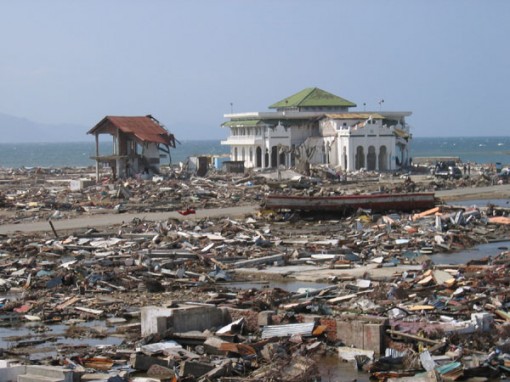
Devastation in Banda Aceh, on the north tip of Sumatra. Only the mosque in the center of the city stood. (Courtesy USGS).
The disaster could have been even worse, but many people in Indonesia were familiar with earthquakes and tsunamis, and knew to run to higher ground after the quake ended. Most of the tourists, however, and a lot of the locals had no idea what was happening, or were seduced by the unexpected bounty of fish flopping around for easy collection as the sea retreated. On a beach in Phuket, Thailand, a 10-year-old British tourist had studied tsunamis in her geography class, and recognized that the receding ocean and frothing bubbles meant disaster. She warned her parents, and the entire beach was evacuated, resulting in no loss of life. A biology teacher from Scotland recognized the signs at Kamala Bay north of Phuket, and took a busload of vacationers and locals to safety on higher ground.
When large earthquakes, submarine landslides, or volcanoes displace the sea floor, they also create a pulse of energy up and away from this displacement that becomes a wave propagating outward in all directions like ripples on a pond. These waves are very long in wavelength and low in amplitude, so they only cause the sea to swell up a few meters in the open ocean, and are usually difficult to detect by boats at sea. However, as they approach the shallows near land, the sea bottom disrupts the motion of the wave, which has a very deep wave base. The swells begin to pile up near the coast and rise up out of the ocean, forming enormous waves much larger than produced by any storm or surf event. In contrast to the Hollywood stereotype of a beautifully curved wall of water rising higher than buildings, a real tsunami typically looks like any ordinary foamy, crashing, breaking wave, only much larger. The biggest difference between a tsunami and a normal sea wave is that the energy does not end in the normal surf zone, but the water rushes far inland, sweeping through towns and leveling buildings with its enormous power.
The 2004 Indian Ocean tsunami was so catastrophic that the world soon learned a lot about this relatively rare phenomenon. The name tsunami comes from the Japanese word for “harbor wave”, since the Japanese have experienced many of these events connected with frequent offshore earthquakes. A tsunami is a seismic sea wave caused by a sudden displacement of water in the ocean, such as during an earthquake, submarine landslide, or volcanic eruption. It is emphatically NOT a “tidal wave” since it has nothing whatsoever to do with the tides, nor with the waves formed by the winds of storms. One of the few positive outcomes of the 2004 Indian Ocean event is that people all over the world soon became familiar with this distinction, and the media stopped using the misleading term “tidal wave” after using this misnomer for decades. (A pet peeve of many geologists, including myself).
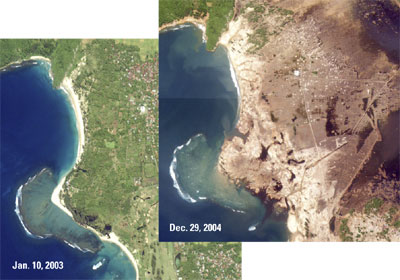
Before and after satellite images of northern Sumatra around Banda Aceh. The areas that were once green turned brown after the tsunami washed the forests and cities away, and killed all the plants with salt water (Image courtesy USGS).
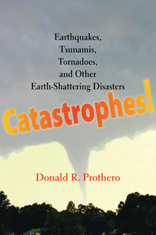
I vividly remember that morning ten years ago, because we woke up and it was all over the news as the horror stories kept flowing in. Just as I remember 9/11 from the early news reports and can vividly recall exactly where I was and what I was doing when I heard it, so too with the news of the 2004 tsunami. Where were you when you heard the news? In my case, my wife said, “You teach about this stuff every semester. Why don’t you write a book about it?” It took a few years, but eventually led to my 2011 book Catastrophes! Ironically, shortly after that book was released, the March 2011 tsunami in Sendai, Japan, occurred.
The loss of life is still not precisely known, but is estimated about 230,000, making it one of the deadliest natural disasters in recent history. The loss of life was much greater than it should have been, because many people in other parts of the Indian Ocean drowned unnecessarily, even though there could have been several hours of warning before it struck. There was no warning, because tsunami are so rare in the Indian Ocean that there was no warning system in place. By contrast, the Pacific Rim has a good warning system in place, because most of the world’s tsunami occur there. This is because tsunami usually occur with subduction zone earthquakes offshore, and most of the world’s subduction zones are on the “Ring of Fire” surrounding the Pacific Rim; the Indonesian arc is one of the few subduction zones outside the Pacific. Although the loss of life was horrendous, there were a few good consequences of the event as well. The world responded with a huge outpouring of humanitarian relief, and many countries recovered quickly thanks to this effort. Most importantly, the countries of the Indian Ocean were made aware of the dangers of tsunami, so they now have policies in place—and the long-overdue early warning system, like that of the Pacific Rim, is also in place. Let’s hope it makes the difference in saving lives the next time.




One of the sad consequences of the tsunami–sharia law took over Aceh province as a reaction to the presence of foreign aid workers and also people blaming the disaster on their lack of strict faith:
http://www.latimes.com/world/asia/la-fg-ff-tsunami-sharia-20141227-story.html#page=1
That, I believe, is called shoehorning. BTW, what was the name of that 10-year-old British tourist? I believe her first name was Tilly, but I can’t recall her last name.
I remember the event and just how quickly Conspiracy Theorist came out with claims that the ‘real cause’ (Anything from HAARP to a nuclear bomb) was the result of the nefarious plotting of, the United States Government, Big Oil, the Illuminati or any other combination of the three above and space aliens.
The event itself moved me to tears, the conspiracy theories left me agast.
Great to read about this important event on its 10-year anniversary. The article says “The largest loss of life was along the western coast of Indonesia, Malaysia, and Thailand…” however, Malaysia was barely affected. I was wondering about the conclusion in which it’s stated “many countries recovered quickly”…it was my impression that the wounds throughout the area were deep and long-term in virtually every way, from economically to socially to culturally. Only now can they show a few parks built where debris once stood. A few days ago, I posted a story about the new Indian Ocean tsunami warning system. It is in its early stages of deployment, it is untested and it’s not in every country. It might be too early to consider the system as being fully ‘in place’ in a way that may offer security to the areas affected by the 2004 tsunami.
http://en.wikipedia.org/wiki/Countries_affected_by_the_2004_Indian_Ocean_earthquake
Txs for the update.